Chicagoland Ley Line Map
I built this map for a simple reason. I wanted to test a ghost-hunter idea with a basic tool. Plot a bunch of haunted locations. Connect the clusters. See if “lines” show up.
They did.
But the weird part is where they showed up. The three strongest lines track major waterways:
- Des Plaines River.
- Chicago River – North Branch
- Lake Michigan shoreline
So if you came here expecting a mystical grid buzzing under downtown Chicago, I get it. I’ve read the same stuff. But what this map suggests is simpler and more interesting.
This might not be a “ley line” story.
This might be a water story.
TL;DR
I mapped well-known haunted locations in Chicagoland using a few Chicago-area haunting guidebooks and Google Maps.
Three strong “lines” appeared where hauntings cluster.
Those lines follow major waterways, and they seem to converge where the Chicago River meets Lake Michigan.
My takeaway: if there’s a pattern here, it looks more like geography and development corridors than invisible energy.
What I mean by “ley line” for this study
Let’s define terms, because “ley line” means different things depending on who’s talking.
Classic ley lines go back to Alfred Watkins in the early 1920s. His idea focused on straight alignments in the landscape. He argued they were practical “old straight tracks,” basically travel and trade routes marked by features along the way.
Modern paranormal culture often uses “ley lines” to mean something else; invisible energy lines, spiritual currents, power grids, and that kind of thing.
This map uses a third meaning:
A “ley line” here is simply a straight line you can draw through clusters of reported haunted locations.
That’s it. It’s a pattern test. A visual study. A way to ask: are these locations random, or do they bunch up along something real in the environment?
3 Chicago “Ley Lines”
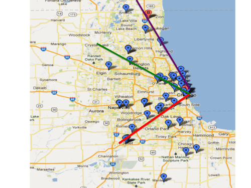
Red line: follows the Des Plaines River
Green line: follows the Chicago River north branch
Purple line: follows the Lake Michigan coastline
Note: There may be another line that tracks east-to-west through Naperville, but I didn’t find enough confirmed haunted places to connect them. This study requires 8 or more, and this track had 5.
In our case, it looks like a large body of water is the link to hauntings vs. a magical or spiritual energy line. It also appears the ley lines converge on the spot where the Chicago River flows into Lake Michigan. Most ghost hunters agree hauntings are more likely near large bodies of water. Even some of the outliers (Antioch, Manteno and Crete) are on streams, ponds and lakes.
Why water might matter … even if you don’t believe in “energy lines”
If you want an explanation, you’ve got a few possibilities that don’t require mystical energy.
A) Chicago grew along water and transport corridors.
Rivers and shorelines shape where people live, work, and build. If hauntings are tied to human activity, then hauntings will cluster where people cluster. Chicago’s waterways are deeply tied to the city’s development.
B) Water corridors overlap with old industry.
Ports, shipping, rail hubs, factories, slaughterhouses, warehouses. A lot of “dark history” sits near rivers and canals because that’s where business moved.
C) Environment changes experience.
Humidity, fog, sound, temperature shifts near water. People notice weirdness when their environment can change fast … like along a massive lake and rushing river.
D) Ghost lore loves water.
Even within paranormal culture, there’s a long-running belief that water amplifies activity. Your map ends up matching that belief, but with a geographic pattern underneath it.
How the map was built (the simple version)
Here’s how I made the ley line map. Nothing fancy about the method at all.
- I pulled well-known haunted locations from a short list of Chicago and Illinois haunting guidebooks.
- I entered addresses into Google Maps (Google MyMaps, specifically) and plotted each location.
- I looked for clusters, and I drew straight lines through the strongest clusters.
That’s the core process.
How to use this map as a ghost hunter
If someone wants to use this for planning, I’d recommend these steps for your ghost hunt:
Step 1: Pick a line, then pick a theme.
Example: “river corridor locations” or “lakefront hotspots.”
Step 2: Confirm access and conditions.
Many sites are private, active businesses, or restricted spaces. This map is a lead generator, not permission. Always get permission to investigate.
Step 3: Go in with a tight experiment.
- Baseline audio (2 minutes)
- Baseline EMF sweep (get readings from the entire building and each room you’ll investigate)
- One controlled EVP session (under 30 minutes)
- Exit interview notes: what did you experience, what can be explained?
Step 4: Compare results across the same line.
If you investigate three locations on the same corridor, do they “feel” similar? Or do they differ wildly? How do your EVP and EMF data compare by location? That’s useful either way.
The Skeptic’s Perspective
I like weird maps. But I’m not going to fool myself.
A few reality checks:
- Humans are pattern-finders. Our brains create something we can understand … fast.
- Cities have dense points of interest. Dense points produce “lines,” especially with grid layouts.
- Old ley-line ideas are widely criticized as pseudoscience, and critics argue alignments are often the product of selection and coincidence.
- Even historically, Watkins framed his lines as practical tracks of human movement, not “energy beams.”
So here’s my take on this ley line study:
This map does not prove ley lines exist. It does suggest that haunted hotspots in Chicagoland cluster along water, and the development corridors built around it.
Bibliography
Broome, Fiona. Ley Lines for Ghost Hunters: An Introduction (Ghost Hunting with Ley Lines, Book 1). 2012.
Kleen, Michael. Haunting Illinois: A Tourist’s Guide to the Weird and Wild Places of the Prairie State. Thunder Bay Press, 2011.
Morris, Jeff, and Vince Shields. Chicago Haunted Handbook: 99 Ghostly Places You Can Visit In and Around the Windy City. Clerisy Press, 2013.
Rice, Jacob. “Chicagoland Ley Line Map.” Ghostly Activities, Apr. 12, 2013 (updated Jan. 18, 2016).
Selzer, Adam. The Ghosts of Chicago: The Windy City’s Most Famous Haunts. Llewellyn Publications, 2013.
“Chicago River.” Encyclopaedia Britannica.
“Des Plaines River.” Encyclopaedia Britannica.
Watkins, Alfred. Early British Trackways, Moats, Mounds, Camps, and Sites. Watkins Meter Co., 1922. Project Gutenberg.
Watkins, Alfred. The Old Straight Track. 1925. (Woolhope Naturalists’ Field Club PDF edition online.)
Woodward, Aylin. “Why people believe in conspiracy theories, astrology and other pseudoscience.” Science News, 2025.
“North Branch Chicago River Watershed.” Metropolitan Water Reclamation District of Greater Chicago.
Have you mapped haunted locations in a large area (like Chicagoland) to see if there’s a pattern? If so, let me know what you found in the comments below.
Thanks for reading Ghostly Activities. Much appreciated and take care!
Discover more from Ghostly Activities
Subscribe to get the latest posts sent to your email.